Skip to content

Adrienne Goudy

Outreach, education, and curriculum development for an urban stormwater college-community partnership

Afflicted by the urban stream syndrome, federal regulations require local municipalities to mitigate the effects of stormwater as a point-source pollutant. Local municipalities, however, rarely have the technical knowledge in hydrology, engineering, stream ecology, education, and social science to design a holistic management program. Universities and colleges have the opportunity and expertise needed to help local government a) share with communities the latest research on green infrastructure and b) help them plan and implement projects with effective ecological and regulatory effective outcomes. The Lycoming College Clean Water Institute is developing outreach and education programs and providing technical expertise to support local municipalities.

UNMANNED ARIAL INFRARED AND VISUAL LIGHT DATA COLLECTION ON THE WEST BRANCH SUSQUEHANNA

One of the most crucial processes that occurs in the environment is the movement of groundwater and surface water from high elevation to low elevation. This process would not be possible without rivers like the Susquehanna River, draining both ground water and surface water from the central- western areas of Pennsylvania into the Chesapeake Bay. With this being said, it is very important that we understand the processes by which rivers gain or lose water, in order to better understand the watershed as a whole. One of the best ways to better our knowledge of a river is by understanding how they gain or lose water. Finding areas of surface water discharge into river is fairly straight forward but identifying areas where groundwater discharges into the river is much more difficult. Recent technological advances have allowed for the use of thermal drone imaging to detect sites of ground water discharge into rivers by detecting differences in temperature signature within the river. This method works for giving us a better idea of where groundwater discharges, but the cameras ability to see changes in heat signature, as well as quality of the thermal image typically set an obstacle since these zones of discharge are mostly small and the thermal imaging doesn’t have high enough resolution to be able to see small regions of discharge.

We have collected airborne thermal data using a drone (Ebee) along a 2230-meter stretch of the West Branch Susquehanna River adjacent to Bucknell University. 2830 photos were acquired as both visible light images and thermal images over an area of 1.59 km2 for an estimated 2.6 cm/pixel visible light resolution and 15 cm/pixel thermal resolution. The images are being processed and analyzed to evaluate drone infrared imaging and its ability to detect changes in heat signature in the river. The stretch of the river investigated includes definitive surface water tributaries into the river and sections with no tributaries. Given that the locations where surface water discharge enters the river is known, it is possible to use this information to detect other temperature changes within the river in order to find areas where ground water may be discharging into the river. This could help us pinpoint where groundwater discharge may be occurring, and then in the future, it would be possible to carry out geophysical testing of sediment and rock permeability and therefore develop an accurate understanding of where permeable areas reside near the Susquehanna River The initial evaluation of the data indicates that there are significant changes in the temperature of earth’s surface related to buildings, as well as subtle changes within the river. We expect to present available results and interpretations based on the available processed data and relative potential contribution of surface water temperature changes in ground water.

Using large woody debris in streams to restore biodiversity of complex valley floor landscapes

Valley floor landscapes contain a variety of aquatic and semiaquatic habitats that depend on interactions between microtopography and the groundwater table. Historical logging in Pennsylvania frequently used stream channels to move timber downstream to mills along rivers, resulting in catastrophic channel erosion that deepened stream channels, lowered groundwater tables, created single-channel streams, and reduced stream-floodplain connections. These hydrologic and morphologic changes reduced the number, complexity, and area of aquatic habitats across valley floors. However, restoring large woody debris to stream channels can reverse these degradation processes by retaining sediment and organic debris, building up stream bed elevations, and elevating the water table, all of which could combine to reconnect stream and groundwater with former aquatic habitats across the valley floor. Increasing the variety and area of aquatic habitats across the valley floor will likely increase local biodiversity of many groups of organisms, from plants to amphibians, and could lead to higher connectivity and gene flow of certain habitat-limited populations across the region. Large woody debris additions are being performed in several streams in Allegheny National Forest to restore natural channel processes, complex valley floor ecosystems, and corresponding biodiversity. This talk will explore some of the possible ecological benefits of large woody debris additions for aquatic communities in Allegheny National Forest and will consider protocols for assessing biodiversity in restored valley floor landscapes.

Adaptive Management of Aquatic and Riparian Ecosystems Utilizing Large Woody Materials on the Allegheny National Forest: Setting the Stage for the Little Arnot Run Watershed Restoration Project

Trees and fallen woody materials in streams and floodplains create a diversity of habitats for many species. Centuries of removing wood to straighten streams and reduce localized flooding have negatively impacted aquatic and riparian habitats, as well as have exacerbated flooding downstream. The U.S. Forest Service at the Allegheny National Forest (ANF), Western Pennsylvania Conservancy, and other partners are utilizing adaptive management restoration techniques to reestablish historic densities of woody materials in streams across the ANF to restore pre-disturbance ecological conditions. In the Little Arnot Run watershed, project partners are intensively monitoring physical (e.g. streamflow, water table depth, and water quality) and biological (e.g. fish, aquatic insects, and riparian vegetation) parameters to quantify the adaptive management restoration technique’s effects on aquatic and riparian ecosystems. The focus treatment reach on Little Arnot Run is moderately incised and has a relic railroad grade that has cut off the stream from the floodplain. This project will utilize excavators to harvest logs and rootwads materials from local uplands and utilize them to build large wood structures (e.g. cross-channel jams) to raise the bed of the stream in key locations. In addition, barriers such as berms and railroad grades will be removed or cut through to create side channels and reconnect flood flows to the floodplain. The goals of the project are to restore fluvial processes and aquatic habitat, improve water quality, improve distribution of gravel and fines, reconnect floodplains and hyporheic zones, and sequester carbon. This presentation will discuss the location, history, and ecology of the watershed, proposed restoration techniques and goals, and briefly outline several monitoring parameters being developed and implemented.

Research on Methods for Forested Buffer Restoration: Stone Mulch and Tree Tubes

Research on Methods for Forested Buffer Restoration: Stone Mulch vs. Herbicide Spots and Four Types of Tree Shelters.

Stone Mulch as an Alternative to Herbicide Spots in Buffer Plantings: For forested buffer restoration, protecting sheltered trees from rodent damage with 2A modified stone provides a cost-effective alternative to glyphosate herbicide applications. For roughly 15 years, herbicide applications have been a standard prescription for this protection. Concerns for workers, environment and cost led Stroud Water Research Center to test alternatives beginning in 2013, including vole guards, 2” clean stone, and 2A modified stone, which is a mix of particle sizes from very fine to roughly ¾” long dimension. Second generation trials tested 2A modified stone mulch vs. herbicide application. Two stone mulch amounts were tested: 20” diameter x 2” thick (roughly 40 lb) and 12” diameter x 2” thick (roughly 20 lb). Herbicide spots were 36” in diameter, applied 2x/year. Through three growing seasons, either 2A modified stone treatment was as effective as herbicide spots on survivorship, with a slight decline in growth rate for stone treatments. Stone mulch costs roughly 1/3 the cost of typical four-year herbicide applications, and requires 1 mobilization vs. 8 for herbicide use. Loss of stone due to flooding appears to be a minor concern. Access/logistics of getting stone to some sites can be challenging.

Trials of Tree Shelters – Tubex Combitube TM, Plantra TM and Suregreen TM: Tree shelters are commonly used in hardwood plantings to aid growth and survivorship. Stroud Center’s tests of Tubex Combitube (vented), Standard Tubex (non-vented) and Plantra (vented) – all 5’ tall – showed no significant differences in growth or survivorship through three years. Tests of Combitube vs. Plantra vs. Suregreen TM (vented) showed no significant differences after one growing season. Among these commonly used shelters, data to date show that secondary considerations (cost, ease of use, availability and other aspects of performance) can guide selection.

Evaluating the Impact of Stream Restoration Techniques on Bank Erosion and Stream Morphology at an Unnamed Tributary of Pine Creek near Woodward, Central Pennsylvania

Soil bioengineering techniques are commonly used and effective in stream restoration projects in the United States. Live staking, specifically, is a soil bioengineering technique that is considered to be an economically viable and easy technique for stream restoration. Evaluations of restoration success rarely focus on the geomorphology of a stream, and commonly focus on the riparian ecosystem. This research project is investigating the impact of live staking on bank erosion and stream morphology in an unnamed tributary of Pine Creek near Woodward, Central Pennsylvania, approximately 20 miles west of Bucknell. This tributary has both
a restored section that has undergone live staking, and an unrestored section. It is also the subject of ongoing ecological studies by the Penn’s Valley Conservation Association (PVCA), but there have not yet been any studies implemented on the geomorphology of the tributary. For this research project, we are comparing the restored section to the unrestored section of the tributary to evaluate how live staking is affecting bank erosion, stream morphology, and soil organic matter (SOM). Field methods we are using include drone-based photogrammetry, surveying with a terrestrial LiDAR Scanner, high-resolution GPS data with a Trimble Real-Time Kinematic GPS unit, and soil sampling along the floodplain of the tributary using a soil
corer. Preliminary results suggest that the range of soil organic carbon in the floodplain soils is 0.5 to 2 percent. The soils are primarily a silty loam containing significant amounts of orange mottles and rootlets. The current state of the stream includes silt on the stream bed, undercut banks, and a very low current. This baseline data will be a fundamental part of a long-term study of the geomorphic processes acting in a bioengineered riparian ecosystem.

Viability of live stake species: bud production, herbivory, and the effects of rooting hormone and herbicide treatments

Live stakes are woody cuttings from wetland tree species that can root naturally when pounded into the ground. The use of live stakes in riparian and wetland restoration is becoming an increasingly popular technique because of its relatively low costs and maintenance requirements. However, the success of live stakes depends on species, environmental conditions, and planting conditions such as artificial rooting hormone or weed control strategies. The impact of such factors has not been widely studied, and much more research is available for western species and conditions than for those of eastern North America. We collected data in May 2020 using a common garden experiment with 1,550 stakes of nine native Pennsylvania species, where manipulated variables included the use of herbicide to control invasive species and rooting hormone to encourage root growth of stakes. Stakes were randomly blocked by species, and we examined what effect the use of herbicide, the use of rooting hormone, herbivory, presence of poison hemlock, species, stake diameter, and planting depth of stakes had on survival and number of buds produced. Our preliminary mixed effects model suggests that there is a positive relationship between stake diameter and number of buds and that when rooting hormone was used, stakes had more buds on average. It also suggests that most the species had similar high initial survival rates (>80%), except northern spicebush (57%), and that most species were consumed by herbivores at similar rates, except elderberry, which had more than twice the herbivory of any other species. When poison hemlock was present, stakes also had more buds on average. We hope to provide an analysis that will help conservation professionals gain insight into which local live stake species are most able to survive and quickly produce buds, and whether the use of rooting hormone or presence of poison hemlock impact survival or growth. Due to the global coronavirus pandemic, our site was not maintained this summer and is significantly overgrown. Therefore, we will repeat data collection in the coming months to identify which species are likely to have the greatest success at sites where maintenance is difficult or impossible.

Fluvial Geomorphology and Hydrology of Little Arnot Run, Allegheny National Forest, Pennsylvania

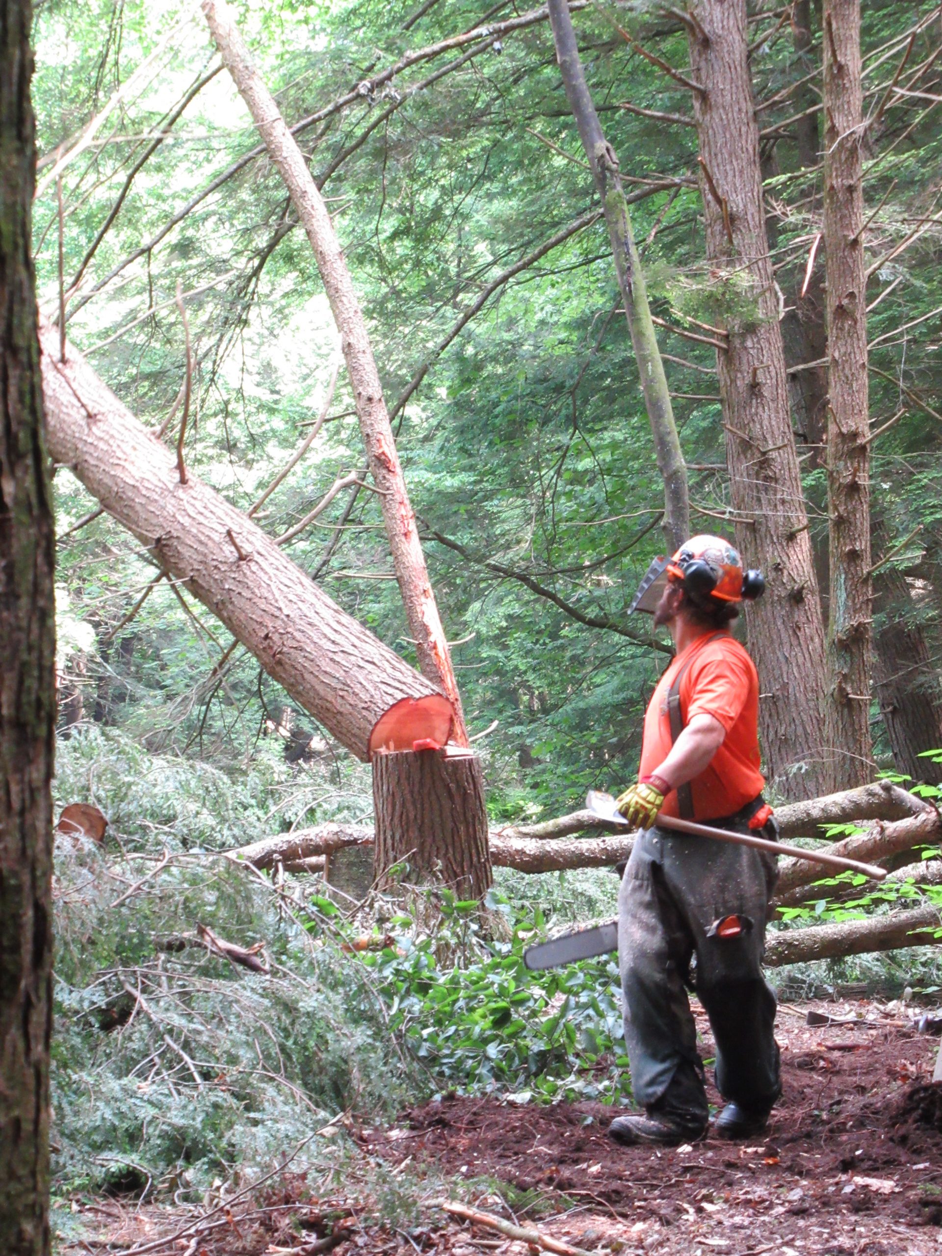
To help direct stream restoration activities scheduled to begin in 2021 in the Little Arnot Run (LAR) watershed of the Allegheny National Forest (ANF), we have been characterizing the factors controlling geomorphic processes operating with the watershed. Baseline hydroclimatic data are recorded every 15 minutes using a network of instruments, including a weather station, piezometers, stream gages, water quality sonde, and temperature sensors placed on the bed of the stream. A survey of stream and floodplain features along a 6.8 km length of the lower and middle reaches of the valley was conducted to characterize the stream at the reach- and channel-unit scale. The survey included inventory of large woody debris (LWD), the dimensions of bedforms and channel features such as pool/riffle/run/glide/cascades, width/depth measurements, pebble counts, and observations of channel bed and bank material, root strength, bank height and cohesiveness, evidence of historic alteration, etc. Synoptic measures of flow velocity, shear stress, and discharge are also being collected at selected locations in the channel.
At the reach scale, anthropogenic factors are the dominant influence on the channel morphology, which remains in a protracted phase of adjustment to alterations done during the 19th and 20th century. Relic logging berms, steam railroad grades, and oil infrastructure can be found throughout its lower and middle reaches. In many places the stream was dredged, straightened, and converted to a single-thread channel that is narrow and deep and remains disconnected from side channels up on the floodplain. Relic oil pipes and exploration pits are scattered throughout the floodplain, with broken pipes spanning the channel in several places; at least 12 oil well pads with J-pumps are active today. All these factors are under consideration as part of the restoration strategy.
At the channel unit scale, hydrologic factors are the dominant influence on channel morphology and hyporheic exchange, including bank cohesiveness (% silt and clay), root strength, channel slope, abundance of large woody material, and water and sediment discharge. Average fast water depths ranged from 0.5 to 1.2 m; pool depths ranged from 0.6 to 1.7 m; average wetted widths ranged 4.2m in upper reaches to 5.1 in lower reaches. Average woody material in size class/150m was 2.3 in steep upper reaches and increased to 6.5 in lower reaches, with distinctly less woody material (<1.6) in the proposed restoration reach. Channel slopes varied from 0.09 to 0.18 and averaged 0.014, hydraulic radius 1.4 and roughness coefficients on the order of 0.042. Bed sediment size decreased in a downstream direction, with pools consisting predominantly of well-sorted sand and fine gravel (D50 = 20 to 80mm) and riffles consisting of cobble-boulder in riffles (D50 = 20 to 80mm). Bankfull velocities are estimated to range from 1 to 2.1 ft s-1, with most bed material and large woody debris mobile.
Most of the stream is shaded completely by mature forests, with little to no direct solar radiation. Diurnally, water temperatures vary between 2 and 4°C, showing the greatest variability during the low-flow periods in late summer and winter, when air temperatures vary considerably and buffering from groundwater inputs are low. Seasonal 2019 stream temperatures varying cyclically, with average temps of 1.1°C during the winter (Dec.-Feb.), 6.4°C during the spring (Mar.-May), 16.1°C during summer (Jun.-Aug.) and 7.8°C during the fall (Sep.-Nov.). During the summer months, temperatures increased 1.2°C/km in a downstream direction, largely the result of long-wave atmospheric radiation during the day.
No overbank floods occurred since monitoring began in Dec. 2018. Flows in the stream are relatively short lived in response to rainfall-runoff and snowmelt events, with a time of concentration of less than 6 hours and long recession curve, depending on the amount and duration of precipitation or snowmelt. Elevations of the stream and groundwater surface are recorded every 15 minutes in a network of piezometers and gage stations installed in the channel and adjacent valley alluvium. Following rainfall-runoff events, as stream levels rise, the groundwater table slopes away from the channel and down-valley, resulting in hydrostatic-driven exchange. This hyporheic exchange is driven by static hydraulic gradients which are determined by changes in water surface elevation in the channel, spatial heterogeneity in saturated hydraulic conductivity of the bed and bank material, and changes in the saturated cross-sectional area of floodplain alluvium through which hyporheic flow occurs. Falling-head tests conducted in three piezometers screened in the valley fill deposits indicate that the hydraulic conductivity (K) of the valley alluvium ranges from 4 x 10⁻³ m s-4 to 8 x 10⁻² m s-1, suggesting hyporheic exchange rates could be very high. Limited exposures in well borings and stream banks suggest the valley fill material is laterally heterogeneous and longitudinally anisotropic, with highly permeable gravel/cobble layers likely controlling patterns of interfacial flux and flow paths. Additional work is underway to determine the rates and directions of hyporheic exchange, which greatly influences stream ecosystem processes and bio-geochemical cycles in Little Arnot Run and will be an important component of the restoration and management plan of this watershed and others throughout the Allegheny National Forest.

Improving Riverine Flood Hazards Estimation Using an Integrated Modeling Approach

Floods drive devastating climate-related disasters. These risks are expected to rise with environmental and
demographic changes. A sound understanding of dynamic flood hazards is crucial to inform the design and
implementation of flood risk management strategies. We develop a framework to assess riverine flood risks for
current and projected climate conditions. We implement the framework for rivers across the state of Pennsylvania,
United States. Our projections suggest that flood hazards across Pennsylvania are overall increasing with future
climate change. The analysis requires an integrated approach since the uncertainty in flood inundation
projections is impacted by uncertainties surrounding climate change, and hydrodynamic model structure and
parameter. We will discuss how this framework can provide regional and dynamic flood-hazard assessments and
help to inform the design of risk management strategies.

Genetic diversity & connectivity of Chasmanthium latifolium (Poaceae) in Pennsylvania & the effect on conservation status

Chasmanthium latifolium (Poaceae) is a rhizomatous perennial plant species that lives in close proximity to rivers and streams, making it fittingly referred to as river oats. Native to the southern midwest and the eastern half of the United States, C. latifolium reaches the northeastern edge of its range in Pennsylvania. Chasmanthium latifolium (Poaceae) is comprised of two metapopulations that exhibit an east-west disjunction within Pennsylvania, one metapopulation around the Allegheny River, and one around the Susquehanna River. Due to the limited and isolated distribution of the species within the state, as well as declining populations, C. latifolium is considered a critically imperiled (S1) plant in Pennsylvania by the Pennsylvania Natural Heritage Program (PHNP) but is ranked as tentatively undetermined by the state. My study aims to achieve two main objectives: 1) investigate the genetic diversity and connectivity of the two metapopulations, and 2) revise the conservation status and develop scientifically informed policies to better conserve this species. This research utilizes a genotype-by-sequencing (GBS) approach to generate genomic data for use in population genetics analyses. By employing iPyrad and packages in the R statistical computing software to synthesize these data, I will gain insight into gene flow and the genetic stability of these metapopulations. Ultimately, my research will provide an updated, scientifically-backed conservation status assessment of C. latifolium in Pennsylvania. This project will combine rare plant survey protocols by the Pennsylvania Natural Heritage Program and Western Pennsylvania Conservancy and genetic work at Bucknell University to address broad conservation questions.