background-img

Oral Presentations

Outreach, education, and curriculum development for an urban stormwater college-community partnership

Afflicted by the urban stream syndrome, federal regulations require local municipalities to mitigate the effects of stormwater as a point-source pollutant. Local municipalities, however, rarely have the technical knowledge in hydrology, engineering, stream ecology, education, and social science to design a holistic management program. Universities and colleges have the opportunity…

UNMANNED ARIAL INFRARED AND VISUAL LIGHT DATA COLLECTION ON THE WEST BRANCH SUSQUEHANNA

One of the most crucial processes that occurs in the environment is the movement of groundwater and surface water from high elevation to low elevation. This process would not be possible without rivers like the Susquehanna River, draining both ground water and surface water from the central- western areas of…

Using large woody debris in streams to restore biodiversity of complex valley floor landscapes

Valley floor landscapes contain a variety of aquatic and semiaquatic habitats that depend on interactions between microtopography and the groundwater table. Historical logging in Pennsylvania frequently used stream channels to move timber downstream to mills along rivers, resulting in catastrophic channel erosion that deepened stream channels, lowered groundwater tables, created…

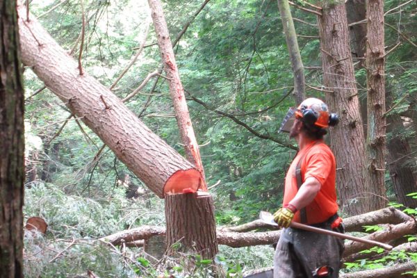
Adaptive Management of Aquatic and Riparian Ecosystems Utilizing Large Woody Materials on the Allegheny National Forest: Setting the Stage for the Little Arnot Run Watershed Restoration Project

Trees and fallen woody materials in streams and floodplains create a diversity of habitats for many species. Centuries of removing wood to straighten streams and reduce localized flooding have negatively impacted aquatic and riparian habitats, as well as have exacerbated flooding downstream. The U.S. Forest Service at the Allegheny National…

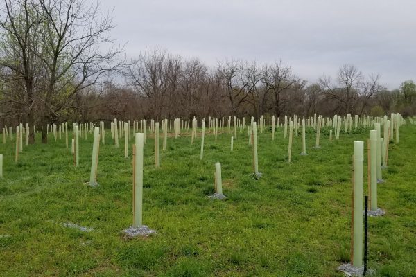
Research on Methods for Forested Buffer Restoration: Stone Mulch and Tree Tubes

Research on Methods for Forested Buffer Restoration: Stone Mulch vs. Herbicide Spots and Four Types of Tree Shelters. Stone Mulch as an Alternative to Herbicide Spots in Buffer Plantings: For forested buffer restoration, protecting sheltered trees from rodent damage with 2A modified stone provides a cost-effective alternative to glyphosate herbicide applications…

Evaluating the Impact of Stream Restoration Techniques on Bank Erosion and Stream Morphology at an Unnamed Tributary of Pine Creek near Woodward, Central Pennsylvania

Soil bioengineering techniques are commonly used and effective in stream restoration projects in the United States. Live staking, specifically, is a soil bioengineering technique that is considered to be an economically viable and easy technique for stream restoration. Evaluations of restoration success rarely focus on the geomorphology of a stream…

Viability of live stake species: bud production, herbivory, and the effects of rooting hormone and herbicide treatments

Live stakes are woody cuttings from wetland tree species that can root naturally when pounded into the ground. The use of live stakes in riparian and wetland restoration is becoming an increasingly popular technique because of its relatively low costs and maintenance requirements. However, the success of live…

Fluvial Geomorphology and Hydrology of Little Arnot Run, Allegheny National Forest, Pennsylvania

To help direct stream restoration activities scheduled to begin in 2021 in the Little Arnot Run (LAR) watershed of the Allegheny National Forest (ANF), we have been characterizing the factors controlling geomorphic processes operating with the watershed. Baseline hydroclimatic data are recorded every 15 minutes using a network…

Improving Riverine Flood Hazards Estimation Using an Integrated Modeling Approach

Floods drive devastating climate-related disasters. These risks are expected to rise with environmental and demographic changes. A sound understanding of dynamic flood hazards is crucial to inform the design and implementation of flood risk management strategies. We develop a framework to assess riverine flood risks for current and projected climate conditions. We implement…

Genetic diversity & connectivity of Chasmanthium latifolium (Poaceae) in Pennsylvania & the effect on conservation status

Chasmanthium latifolium (Poaceae) is a rhizomatous perennial plant species that lives in close proximity to rivers and streams, making it fittingly referred to as river oats. Native to the southern midwest and the eastern half of the United States, C. latifolium reaches the northeastern edge of its range in Pennsylvania…

Aquatic Warming Stripes: Visualizing Climate Change Impacts to Freshwater Ecosystems

Warming stripes plots are a simple yet powerful way to convey large amounts of data. These plots show a series of bars filled with colors that represent annual temperatures, which allows clear communication of temperature changes throughout time. To date, air temperature data has most often been portrayed using warming…

Restoration Reports: A landowner outreach and communication tool from design to farmer outreach

If you are a landowner interested in installing conservation practices on your property, it can be daunting to figure out the full scope of options and who to contact to start this process. This challenge has been known to inhibit many individual property owners who own farms, woodlands, or residential…

Improving stream restoration projects: how instream habitat influences recruitment and distribution of aquatic insects

Aquatic insects have complex life cycles which often involve interactions with aquatic and terrestrial environments. Many insects rely on the presence of instream habitats, like riffles, to successfully complete multiple life stages. Riffles are particularly important for recruitment of insects that exclusively oviposit (lay eggs) on microhabitat like rocks or…

Going Rogue: Science communication lessons from Twitter “alt” government accounts

Microblogging platforms provide an opportunity to reach audiences with a speed and scale much greater than traditional communication methods. They also present a vast source of publicly available data to analyze and identify successful or ineffective past practices in communication. Following the 2017 presidential inauguration ceremony, the active restriction of…

GIS-based prioritization system for MS4 compliance projects

The Clean Water Act regulates discharges of pollutants into streams and rivers, which includes point source discharges. This research aims to determine a framework for prioritizing best management practices (BMPs) and locations in urbanizing areas to fulfill the MS4 requirements. A list of criteria for BMP selection and placement was…

Challenges, barriers, and misunderstandings for implementing small-municipality MS4 programs

Federal regulations for municipal separate storm sewers (MS4) in the United States have been in place since 1990 as part of the Nation Pollutant Discharge Elimination System (NPDES), aiming to reduce sediment and pollutant loads originating from urban areas. However, small-municipality MS4 permittees frequently face several common challenges, barriers…

Assessment of small tributaries as possible habitats for larvae and juveniles of Japanese giant salamanders, Andrias japonicus, by coupling environmental DNA with traditional field surveys

Demographic assessments of all four cryptobranchid salamander species have continued to indicate declines over the past several decades. One of the conservation challenges facing all cryptobranchid salamanders is the paucity of information about larvae and juveniles. Larvae and juveniles have only rarely been encountered during field surveys, even in streams…

Carrying Capacity in Suburban Ecological Communities

Regionally in the northeastern hardwood forest ecosystems, the use of alien plants for ornamental horticulture, the escaping of those plants as invasive species, and the deliberate removal of native vegetation in the process greatly limits carrying capacity for migratory birds. Invasive plant species disrupt the natural succession of unused…

Stormwater Offsets: Applying Agricultural BMPs to help meet Municipal Obligations

This presentation will summarize the findings and recommendations of a USDA NRCS Conservation Innovation Grant that explored the feasibility of municipalities achieving required stormwater pollutant reductions by implementing select best management practices on agricultural lands. project team worked directly with four municipalities in Lancaster County to gauge municipal interest in…

Using Elevation Data to Produce an Updated Hydrography Dataset for the State of Pennsylvania

The Pennsylvania Department of Conservation and Natural Resources (DCNR) Bureau of Geological Survey (BGS) has compiled a comprehensive workflow that will be used to generate hydrography data for the new elevation-derived Pennsylvania Hydrography Dataset (PAHD). This workflow relies primarily on geomorphon classification of (QL Level 2) lidar-derived elevation data as…

How a Karst Watershed Swallowed Half of the Excess Rainfall in Its Wettest Year Ever

63.75 inches of rainfall and snowmelt water made 2018 the wettest year in 122 years of record for the Spring Creek Watershed in Centre County, PA. Yet it experienced very limited overbank stream flooding even though its 30-year average annual precipitation of 40.66 inches was exceeded by 57%…

Conservation genomics of Pennsylvania-threatened Baptisia australis var. australis: an investigation in riparian gene flow

The perennial wildflower, Baptisia australis var. australis (L.) R. Br. is found along only four waterways in Pennsylvania: the Allegheny River, Youghiogheny River, Clarion River, and Red Bank Creek. Because of its limited distribution and small number of extant populations, B. australis var. australis is considered state-threatened in Pennsylvania. In…