Skip to content

Adrienne Goudy

Aquatic Warming Stripes: Visualizing Climate Change Impacts to Freshwater Ecosystems

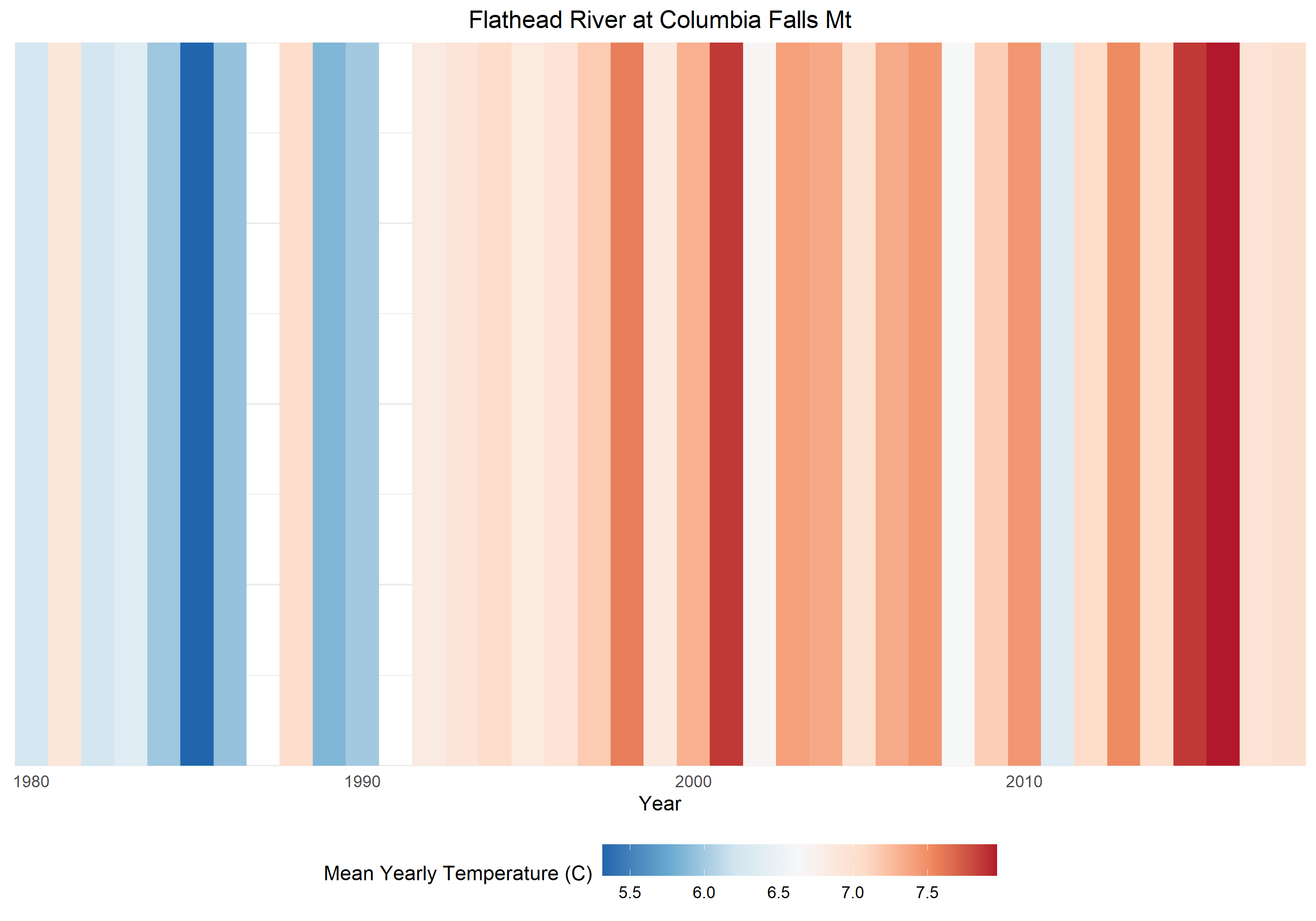
Warming stripes plots are a simple yet powerful way to convey large amounts of data. These plots show a series of bars filled with colors that represent annual temperatures, which allows clear communication of temperature changes throughout time. To date, air temperature data has most often been portrayed using warming stripes plots. I have adapted this concept to visualize water temperature data in rivers and streams. I acquired U.S. Geological Survey water temperature data across the U.S., comprised of >2.2 million observation from 224 stations across the U.S. that have been continuously monitoring water temperature for ≥10 years. These observations were summarized into mean annual temperature and presented in a website that allows users to view sites interactively on a map, and then view warming stripe plots of their choosing. The results demonstrate that although freshwater ecosystems are complex and dynamic, water temperatures are rising rapidly. This is consistent for watersheds in arctic and tropical climates alike. This presentation will provide an overview of the methods employed, a tutorial of the interactive website, and an invitation for those with additional data to contribute so that spatial coverage is enhanced. Currently, stations available within Pennsylvania are limited to the Delaware River watershed; datasets within the Susquehanna River are of significant interest.

Restoration Reports: A landowner outreach and communication tool from design to farmer outreach

If you are a landowner interested in installing conservation practices on your property, it can be daunting to figure out the full scope of options and who to contact to start this process. This challenge has been known to inhibit many individual property owners who own farms, woodlands, or residential property from pursuing conservation practices on their land, because the number of opportunities are overwhelming and a starting point is hard to identify.

Chesapeake Conservancy and American Farmland Trust have partnered to create a science-communication tool to summarize opportunities in an easy-to-digest printout for restoration practices specific to a landowner’s property. Restoration Reports.com is an easy-to-use online tool where a landowner can enter their address and management priorities, and receive a customized, understandable report of potential conservation and restoration practice options. Using high-resolution data and the latest geospatial technology, the Conservancy can tailor each report to the property level, and suggest appropriate points of contact for a landowner to get started. This presentation will discuss the challenge of reaching property owners in conservation and present a case study of how this tool was developed using GIS technology and applied to American Farmland Trust’s Women for the Land Initiative to reach women landowners and land managers. Restoration Reports is now available for landowners in nine Pennsylvania counties.

Improving stream restoration projects: how instream habitat influences recruitment and distribution of aquatic insects

Aquatic insects have complex life cycles which often involve interactions with aquatic and terrestrial environments. Many insects rely on the presence of instream habitats, like riffles, to successfully complete multiple life stages. Riffles are particularly important for recruitment of insects that exclusively oviposit (lay eggs) on microhabitat like rocks or organic material. Riffles are also home to diverse larval communities that often serve as a source of individuals to proximal downstream habitat. We sought to investigate the extent to which instream habitat limits recruitment and community diversity of aquatic insects due to lack of suitable oviposition habitat and isolation of instream habitat patches.

To accomplish this, we constructed nine gravel and cobble riffles in a small central Pennsylvania stream previously lacking coarse inorganic and emergent substrate. These riffles were constructed in sets with different inter-riffle distances (15, 10, or 5 m) to determine if distance to upstream riffle and oviposition habitat affected downstream benthic invertebrate density. Benthic and drift samples were collected directly below each riffle and set of riffles every two weeks from September-October 2019. Riffles were also sampled for aquatic insect eggs, which were reared to adulthood in the lab. Composited Surber samples were also taken from constructed riffles and non-riffle habitat at the end of the experiment to compare community diversity between habitat types.

Initial results suggest that addition of emergent substrate increased insect recruitment to our stream, as 88% of egg masses were found on emergent rocks in riffles compared to 12% of egg masses on fully submerged rocks. Egg masses from Hydropsyche sp. (Trichoptera) and Chironomidae (Diptera) were found on both types of substrate, while Baetis sp. (Ephemeroptera) egg masses were only found on emergent rocks, which suggests that recruitment of taxa with selective oviposition behaviors could be limited by availability of emergent rock substrate. Additionally, larval insect densities were higher in reaches with riffles spaced 5 m apart (276.3 +/- 29.6) than in the control reach upstream of the constructed riffles (mean 113.7 +/- 7.6; ANOVA with Tukey’s pairwise comparison, p < 0.05). This study increased our knowledge of insect oviposition behavior and showed that providing oviposition and riffle habitat for aquatic insect taxa could improve recolonization and ecological recovery following restoration of habitat-limited streams. We suggest strategic riffle addition, including emergent substrate, as an augmentation of conventional structural restoration practices in streams.

Going Rogue: Science communication lessons from Twitter “alt” government accounts

Microblogging platforms provide an opportunity to reach audiences with a speed and scale much greater than traditional communication methods. They also present a vast source of publicly available data to analyze and identify successful or ineffective past practices in communication. Following the 2017 presidential inauguration ceremony, the active restriction of science communication by the Trump administration led to the creation of many unofficial and alternative, or “alt”, Twitter accounts for government agencies to maintain communication. Alt accounts quickly attracted many followers (e.g., 15 accounts with >100,000) and received a large amount of media attention. We analyzed tweets from paired “alt” and official U.S. government agency accounts to compare communication strategies and determine what elements of a tweet make it more likely to accrue attention (likes or shares). We found adding links, images, hashtags, and mentions, as well as expressing angry and annoying sentiments all increased retweets and likes. Evidence-based terms such as “peer-review” had high retweet rates; but linking directly to peer-reviewed publications decreased attention compared to popular science websites. Word choice and attention did not differ between account types, indicating topic was more important than source. The number of tweets generated, and attention received by, alt accounts rapidly decreased after the creation of these accounts, demonstrating the importance of timeliness in science communication on social media. Together our results show potential pathways for scientists to increase efficacy in social media communications.

GIS-based prioritization system for MS4 compliance projects

The Clean Water Act regulates discharges of pollutants into streams and rivers, which includes point source discharges. This research aims to determine a framework for prioritizing best management practices (BMPs) and locations in urbanizing areas to fulfill the MS4 requirements. A list of criteria for BMP selection and placement was generated and GIS data consistent with the criteria were created to generate a spatial model identifying ideal BMP locations. Suitable locations for BMP’s are limited in river-towns such as Williamsport, PA. Working with local managers can improve models to help identify unintuitive locations for BMP locations, but overall prioritization systems are useful for MS4 regulated regions.

Challenges, barriers, and misunderstandings for implementing small-municipality MS4 programs

Federal regulations for municipal separate storm sewers (MS4) in the United States have been in place since 1990 as part of the Nation Pollutant Discharge Elimination System (NPDES), aiming to reduce sediment and pollutant loads originating from urban areas. However, small-municipality MS4 permittees frequently face several common challenges, barriers, and misunderstandings in their efforts to regulate stormwater. We summarize common challenges and misunderstandings concerning MS4 management and offer real-world examples of effective approaches for satisfying MS4 requirements. For example, many municipalities see no funding mechanism for implementing stormwater plans, and small municipalities are at a particular disadvantage in the absence of direct federal or state funding. Taxes are a potential mechanism yet often unpalatable to local municipalities. Grants or the creation of a stormwater utility can offset costs to local communities but also face barriers to implementation. Additionally, best management practices (BMPs) can improve stormwater quality but benefits to the local community from improved water quality are often poorly understood or mischaracterized. In spite of this, there are several MS4 management approaches that may be more approachable, including forming coalitions, forming stormwater utilities, and establishing monitoring programs. Small municipalities can benefit greatly from a realistic, facts-based clarification of MS4 policies and practices that lays out all of the options available to achieve NPDES requirements.

Analyzing the Impact of Mine Drainage Residuals on Phosphorus Sequestration and Agricultural Production

Waterways throughout Appalachia and other areas in the United States are impacted by acid mine drainage. Treatment of mine water often results in large quantities of solids, also known as mine drainage residuals, that are typically disposed by burial, landfilling, or pumping back into mine pools. We hypothesize that mine drainage residuals could be beneficially reused in agriculture applications to sorb water extractable phosphorus, potentially increasing the amount of bioavailable phosphorus for crop growth and reducing nutrient runoff to nearby waterways. To test this hypothesis, a greenhouse study was performed to determine if mine drainage residuals could be used to sorb nutrients from dairy manure, reduce nutrient runoff, and improve ryegrass yield. Before the greenhouse study, sorption experiments confirm that phosphates in manure could sorb onto the mine drainage residuals. Additional leaching experiments are also in progress to determine if the sorbed phosphorus is bioavailable for plant growth. For the greenhouse experiments, varying amounts of mine drainage residuals were mixed with cow manure before application to a nutrient deficient soil. Rye grass was then grown in a greenhouse, weighed and harvested. Treatments included a negative control with no manure, a positive control with manure and manure treated with 12 g/L MDR (low dose) and 60 g/L MDR (high dose). Rye grass yield was monitored in the different treatments for 166 days. The addition of the MDR to the manure, even at the highest rate, had no detrimental impact to rye grass yield. Both MDR and positive control treatments had statistically similar yields but were greater than the yields from the negative control. These results indicate that beneficially reusing MDRs in agriculture could help reduce nutrient runoff without impacting crop yield.

Assessment of small tributaries as possible habitats for larvae and juveniles of Japanese giant salamanders, Andrias japonicus, by coupling environmental DNA with traditional field surveys

Demographic assessments of all four cryptobranchid salamander species have continued to indicate declines over the past several decades. One of the conservation challenges facing all cryptobranchid salamanders is the paucity of information about larvae and juveniles. Larvae and juveniles have only rarely been encountered during field surveys, even in streams where adults have commonly been found. In the case of the Japanese giant salamander (Andrias japonicus), several lines of evidence imply that larval and juvenile age classes use different habitats than adults such as small tributary streams, which have been overlooked by conservation monitoring surveys in Japan. We examined small tributary streams as possible habitats for young A. japonicus by integrating eDNA analysis with traditional field surveys. During the summer of 2018, we surveyed three first-to-third order tributaries of the Ichi River in Hyogo Prefecture, Japan, and collected water samples from each stream (Stream A: 465 m stretch, N=8; Stream B: 955 m stretch, N=21; Stream C: 2,331 m stretch, N=22) for eDNA analyses. Although no A. japonicus were observed during the eDNA water sampling, we repeatedly detected A. japonicus eDNA in all streams. Given this result, we conducted field surveys in the summer and fall of 2019, consisting of a daytime survey and a nighttime survey for each of the three streams. During the daytime surveys, we found no A. japonicus in Streams A and B, whereas in Stream C we found one larva, one juvenile, and one new nest with a large adult male actively guarding, from sampling sites that showed notably higher eDNA concentrations. During the nighttime surveys, we found five adults and one juvenile from Stream A, one adult from Stream B, and 13 adults from Stream C. These results suggest the importance of small tributary streams for A. japonicus, especially for smaller breeding adults and likely for larval and juvenile development. There are numerous previously unsurveyed small tributary streams throughout the range of A. japonicus. Our results suggest that the coupling of eDNA analysis with field surveys provides an efficient monitoring tool to examine those overlooked habitats, which would further emphasize the importance of including small tributaries in the conservation management of A. japonicus and potentially the other cryptobranchid salamanders.

Preliminary results from a study of the impact of Walker Lake on the North Branch of Middle Creek using metrics generated by diatom biofilm communities

Middle Creek is a tributary of the main stem of the Susquehanna River, and its watershed is confined mostly to Snyder County. The upper reaches of the stream are defined by two major branches, the North Branch and the West Branch, each of which is interrupted by a reservoir, Walker Lake and Faylor Lake, respectively. Walker Lake is an impoundment of a deep V-shaped valley and is 9-10 meters deep at the dam, which allows it to be stratified in the summer and winter. Summer stratification produces an anoxic hypolimnion, which is drawn off by the bottom outflow dam into the North Branch. During September of 2019 and 2020, the hypolimnion of Walker Lake became anoxic and its outflow below the dam had a strong odor of hydrogen sulfide and deposits of iron (III) oxide-hydroxide covered the cobbles and small boulders. The purpose of this preliminary investigation is to explore the impact of the bottom outflow below the dam and at sample sites downstream before and after fall turnover on the diatom biofilm communities and use them as proxies for the state of the stream. We examined four sites on the North Branch: above the lake (1.5 km above the lake), Walker Lake, below the dam at its outflow, and a site 1.2 km downstream called Old Bridge. Field measurements with a YSI 556 multimeter of pH, conductivity, and % oxygen saturation showed clear impacts when the lake was stratified but began to moderate following fall turnover. The loss of alkalinity and conductivity were particularly noticeable. The alkalinity decreased by 35% between the above site (2,350 µeq/L) and below the dam (1,514.4 µeq). Before turnover, at the below site, biofilm diatoms were scarcely found such that the phytoplankter, Asterionella formosa, which had been flushed from the lake, was the most abundant diatom species encountered from the stones collected at the site. Following turnover, however, the biofilm community reestablished itself and was dominated by Achnanthidium minutissumum in November 2019. Preliminary metrics based on diatom community analysis before and after turnover suggest that the above lake site was impaired by agriculture (indices indicating high levels of sedimentation and nutrient runoff), but the reservoir did not function as a sediment or nutrient trap. Instead, the downstream sites showed higher impairment than the above lake site.

Carrying Capacity in Suburban Ecological Communities

Regionally in the northeastern hardwood forest ecosystems, the use of alien plants for ornamental horticulture, the escaping of those plants as invasive species, and the deliberate removal of native vegetation in the process greatly limits carrying capacity for migratory birds. Invasive plant species disrupt the natural succession of unused farmlands and open spaces. Before suburban sprawl, the spaces between cities were greater and provided a corridor between natural areas. The carrying capacity of highly developed areas can be improved by directly improving the abundance and biodiversity of native vegetation in the first trophic level. By eliminating invasive plant species, replacing alien ornamental species with native alternatives for specialist and generalist insect species, and reducing lawn area, native insect populations increase thereby improving carrying capacity and breeding success of migratory birds. This also has implications for mitigation efforts for other ecosystem processes affected by anthropogenic and environmental risks.