Skip to content

Poster

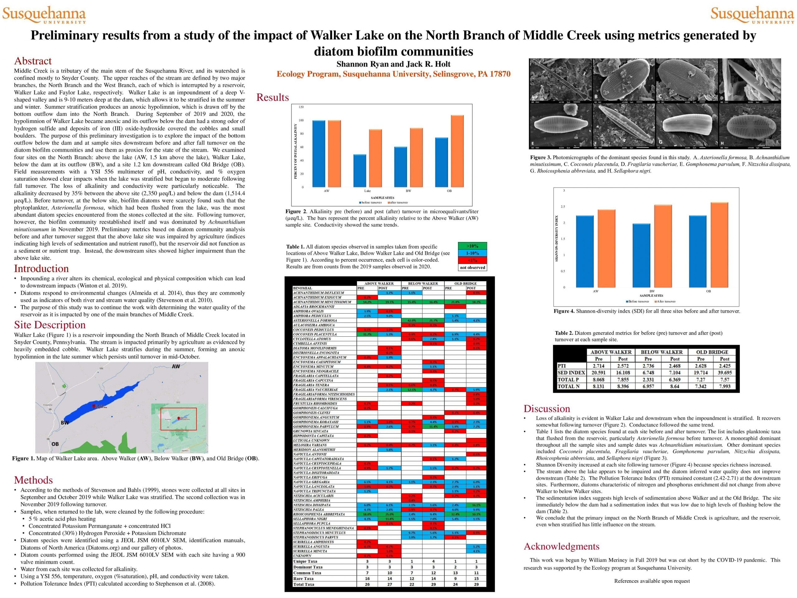
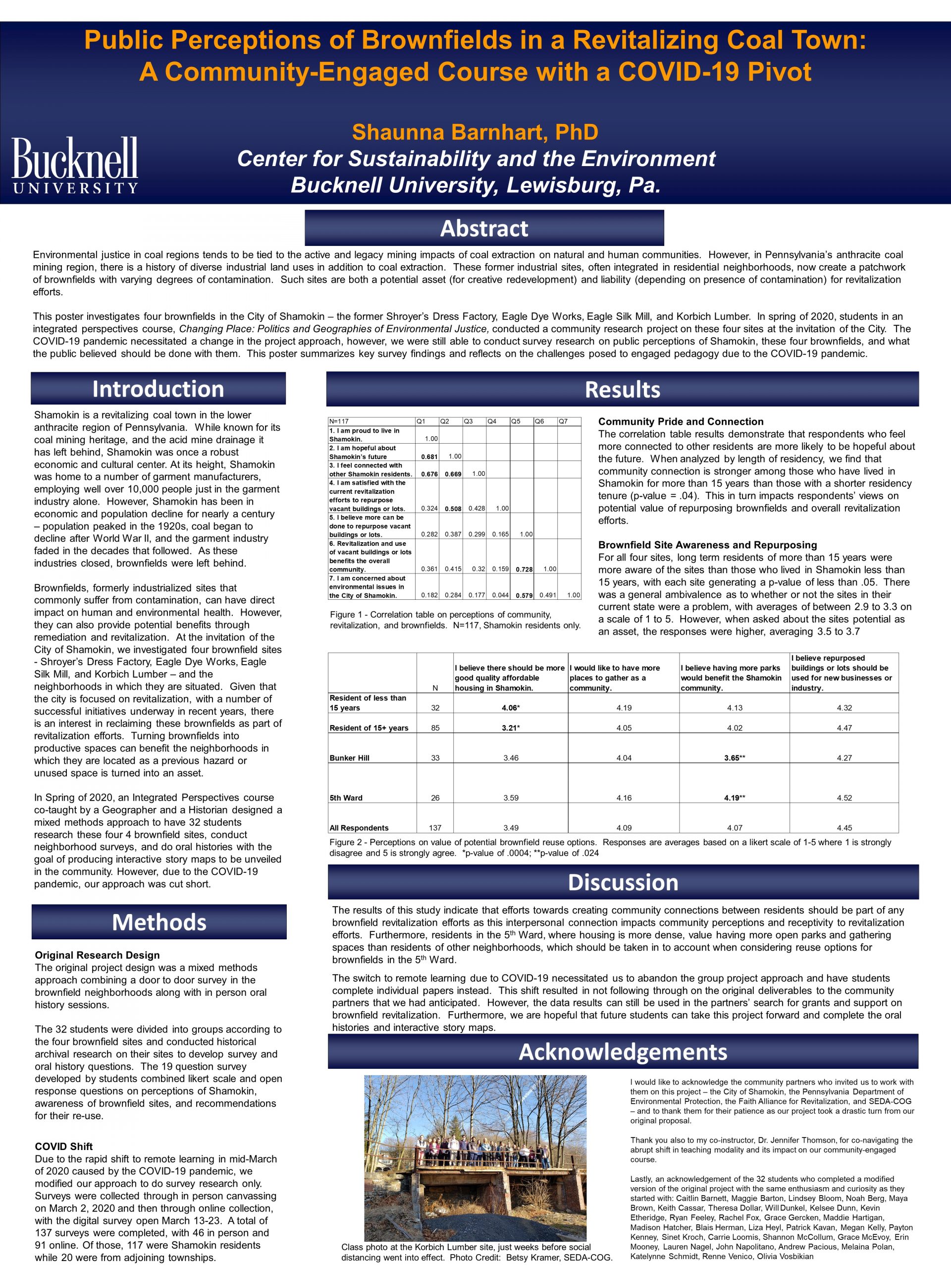
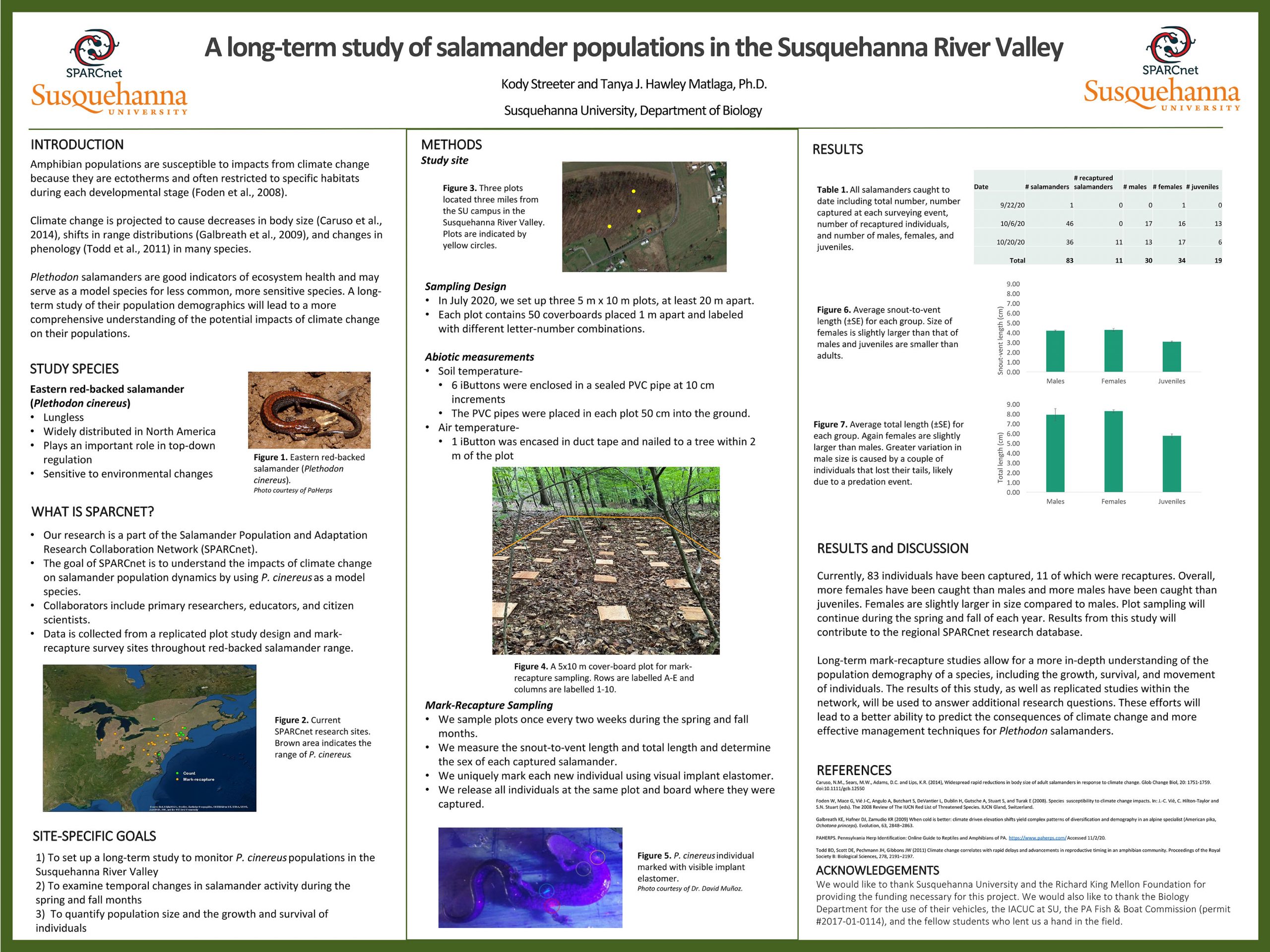
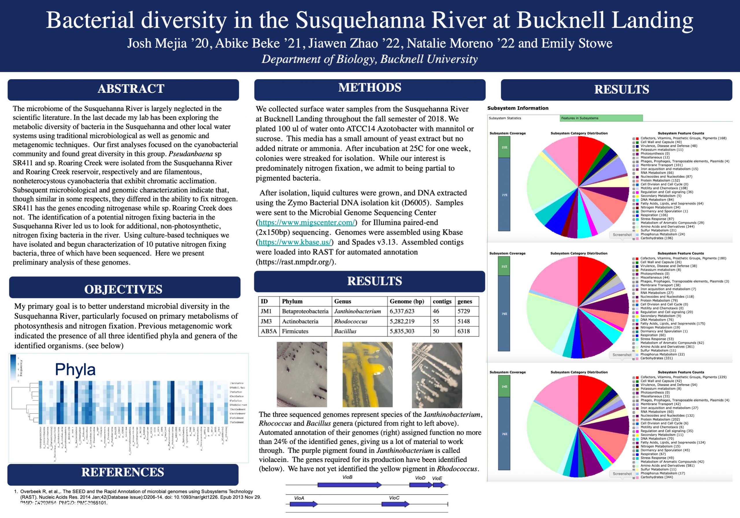
Analyzing the Impact of Mine Drainage Residuals on Phosphorus Sequestration and Agricultural Production

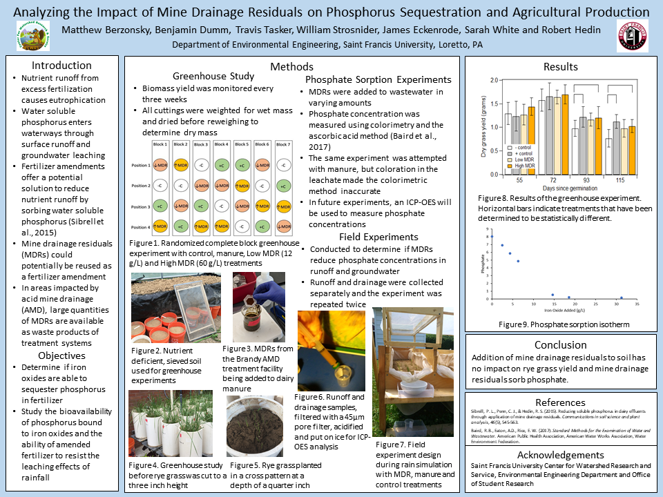
Waterways throughout Appalachia and other areas in the United States are impacted by acid mine drainage. Treatment of mine water often results in large quantities of solids, also known as mine drainage residuals, that are typically disposed by burial, landfilling, or pumping back into mine pools. We hypothesize that mine drainage residuals could be beneficially reused in agriculture applications to sorb water extractable phosphorus, potentially increasing the amount of bioavailable phosphorus for crop growth and reducing nutrient runoff to nearby waterways. To test this hypothesis, a greenhouse study was performed to determine if mine drainage residuals could be used to sorb nutrients from dairy manure, reduce nutrient runoff, and improve ryegrass yield. Before the greenhouse study, sorption experiments confirm that phosphates in manure could sorb onto the mine drainage residuals. Additional leaching experiments are also in progress to determine if the sorbed phosphorus is bioavailable for plant growth. For the greenhouse experiments, varying amounts of mine drainage residuals were mixed with cow manure before application to a nutrient deficient soil. Rye grass was then grown in a greenhouse, weighed and harvested. Treatments included a negative control with no manure, a positive control with manure and manure treated with 12 g/L MDR (low dose) and 60 g/L MDR (high dose). Rye grass yield was monitored in the different treatments for 166 days. The addition of the MDR to the manure, even at the highest rate, had no detrimental impact to rye grass yield. Both MDR and positive control treatments had statistically similar yields but were greater than the yields from the negative control. These results indicate that beneficially reusing MDRs in agriculture could help reduce nutrient runoff without impacting crop yield.

Preliminary results from a study of the impact of Walker Lake on the North Branch of Middle Creek using metrics generated by diatom biofilm communities

Middle Creek is a tributary of the main stem of the Susquehanna River, and its watershed is confined mostly to Snyder County. The upper reaches of the stream are defined by two major branches, the North Branch and the West Branch, each of which is interrupted by a reservoir, Walker Lake and Faylor Lake, respectively. Walker Lake is an impoundment of a deep V-shaped valley and is 9-10 meters deep at the dam, which allows it to be stratified in the summer and winter. Summer stratification produces an anoxic hypolimnion, which is drawn off by the bottom outflow dam into the North Branch. During September of 2019 and 2020, the hypolimnion of Walker Lake became anoxic and its outflow below the dam had a strong odor of hydrogen sulfide and deposits of iron (III) oxide-hydroxide covered the cobbles and small boulders. The purpose of this preliminary investigation is to explore the impact of the bottom outflow below the dam and at sample sites downstream before and after fall turnover on the diatom biofilm communities and use them as proxies for the state of the stream. We examined four sites on the North Branch: above the lake (1.5 km above the lake), Walker Lake, below the dam at its outflow, and a site 1.2 km downstream called Old Bridge. Field measurements with a YSI 556 multimeter of pH, conductivity, and % oxygen saturation showed clear impacts when the lake was stratified but began to moderate following fall turnover. The loss of alkalinity and conductivity were particularly noticeable. The alkalinity decreased by 35% between the above site (2,350 µeq/L) and below the dam (1,514.4 µeq). Before turnover, at the below site, biofilm diatoms were scarcely found such that the phytoplankter, Asterionella formosa, which had been flushed from the lake, was the most abundant diatom species encountered from the stones collected at the site. Following turnover, however, the biofilm community reestablished itself and was dominated by Achnanthidium minutissumum in November 2019. Preliminary metrics based on diatom community analysis before and after turnover suggest that the above lake site was impaired by agriculture (indices indicating high levels of sedimentation and nutrient runoff), but the reservoir did not function as a sediment or nutrient trap. Instead, the downstream sites showed higher impairment than the above lake site.

Public Perceptions of Brownfields in a Revitalizing Coal Town: A Community-Engaged Course with a COVID-19 Pivot

Environmental justice in coal regions tends to be tied to the active and legacy mining impacts of coal extraction on natural and human communities. However, in Pennsylvania’s anthracite coal mining region, there is a history of diverse industrial land uses in addition to coal extraction. These former industrial sites, often integrated in residential neighborhoods, now create a patchwork of brownfields with varying degrees of contamination. Such sites are both a potential asset (for creative redevelopment) and liability (depending on presence of contamination) for revitalization efforts.

This poster investigates four brownfields in the City of Shamokin – the former Shroyer’s Dress Factory, Eagle Dye Works, Eagle Silk Mill, and Korbich Lumber. In spring of 2020, students in an integrated perspectives course, Changing Place: Politics and Geographies of Environmental Justice, conducted a community research project on these four sites at the invitation of the City. The COVID-19 pandemic necessitated a change in the project approach, however, we were still able to conduct survey research on public perceptions of Shamokin, these four brownfields, and what the public believed should be done with them. This poster summarizes key survey findings and reflects on the challenges posed to engaged pedagogy due to the COVID-19 pandemic.

A Long-term Study of Salamander Populations in the Susquehanna River Valley

Amphibians have many biological characteristics that make them sensitive to changes in environmental conditions, particularly climate change. These characteristics allow researchers to use amphibians as indicators of environmental change and explore ways to mitigate adverse effects. The eastern red-backed salamander, Plethodon cinereus, can be used as a model organism in understanding the effects of a changing environment as it is abundant and widely distributed. Following systematic methods of SPARCnet, the Salamander Population and Adaptation Research Collaboration Network, we are investigating the population dynamics of P. cinerus in Selinsgrove, PA. We set up three mark-recapture plots, each containing 50 coverboards, in an area of known salamander presence. During each sampling event, we record soil and air temperature, as well as relative humidity. We measure the size and determine the sex of each salamander and mark each uniquely using visual implant elastomer. We describe our results from sampling events in Fall 2020 including the sex and size distributions of individuals found in the three plots. This long-term research will allow us to gain a comprehensive understanding of the population demographics, such as growth, survival, and movement of individuals over time. Results will contribute to the research network database and will be used to examine demographic patterns of the species across its range. We expect these efforts to lead to a better ability to predict the consequences of climate change and more effective management techniques.

Bacterial diversity in the Susquehanna River and Bucknell Landing

The microbiome of the Susquehanna River is largely neglected in the scientific literature. In the last decade my lab has been exploring the metabolic diversity of bacteria in the Susquehanna and other local water systems using traditional microbiological as well as genomic and metagenomic techniques. Our first analyses focused on the cyanobacterial community and found great diversity in this group. Pseudanbaena sp SR411 and sp. Roaring Creek were isolated from the Susquehanna River and Roaring Creek reservoir, respectively and are filamentous, nonheterocystous cyanobacteria that exhibit chromatic acclimation. Subsequent microbiological and genomic characterization indicate that, though similar in some respects, they differed in the ability to fix nitrogen. SR411 has the genes encoding nitrogenase while sp. Roaring Creek does not. The identification of a potential nitrogen fixing bacteria in the Susquehanna River led us to look for additional, non-photosynthetic, nitrogen fixing bacteria in the river. Using culture-based techniques we have isolated and begun characterization of 10 putative nitrogen fixing bacteria, three of which have been sequenced. Here we present preliminary analysis of these genomes.

Ready Set Fit and Covid-19: Challenges to Collaborative Community-Engaged Student Research in a Pandemic

The COVID-19 pandemic has affected the productive and innovative collaboration between Bucknell students, faculty, and staff and community leaders in the post-industrial river town, Milton, especially with The Improved Milton Experience (TIME). Until the outbreak of the pandemic, Bucknell, Pennsylvania Department of Conservation of Natural Resources (DCNR) and TIME worked together to develop walking paths in the Milton area that accessed historical and cultural information through a smartphone app. In addition to the delivery of information the app also supports a “fitness program” through which walkers can be rewarded for their effort with gift certificates to local Milton businesses after some number of miles walked. However, problems with both the goals of the incentive scheme and the sudden curtailing of university support for community-engaged research during the pandemic have thrown challenges in the way of sustained collaboration.

Creating a Better System: Managing Stormwater and Floods in Pennsylvania

Storm and flood water are managed separately in Pennsylvania due to legislation in the 1970s. Already one of the most flood prone states in the U.S., Pennsylvania faces increased flood and stormwater management challenges going forward. To address how Pennsylvania might better manage storm and flood water going forward, this study analyzed both flood and stormwater laws and implementation at the federal, state, and local level, then compared how these issues are managed by other states. This study offers ideas on how Pennsylvania could create a better flood and stormwater management system to increase compliance, protect people living in flood hazard areas, and reduce the effects of stormwater runoff pollution.

Coliform Trends in Urban Streams receiving Stormwater within Lycoming County MS4

The Clean Water Institute at Lycoming College has been conducting field and laboratory analysis on the urban streams of Lycoming County MS4 region since 2015. The County MS4 includes 9 municipalities/boroughs. Over 200 stormwater outfalls empty into 8 urban streams (Grafius Run, McClure Run, Millers Run, Bull Run, Mill Creek, Tules Run, Mosquito Creek and Hagermans Run) plus Lycoming Creek, Loyalsock Creek and the West Branch Susquehanna River. Quarterly and in some cases monthly samples for chemical analysis ( pH, alkalinity, temperature, dissolved Oxygen (DO), conductivity, Total Dissolved Solids(TDS), nitrite, nitrate, orthophosphate, total phosphorus ) as well as coliforms have been collected from 1-3 sites within 8 urban streams for two years. Membrane filtration was specifically carried out on the water samples to identify the presence of E.coli in them. Fecal contamination may be an indicator of sewage input. This paper provides the trend in coliform count over the years since 2017. The examination of data trends serve as a baseline to be used to implement projects that seek to improve the water quality of the urban streams of Lycoming County MS4 region.

Factors related to recreational visit frequency to freshwater ‘blue space’ in Pennsylvania: the role of restoration and associations with perceived stress

Spending time in areas with aquatic features (‘blue space’) may benefit health through ‘restoration’ from attentional fatigue and emotional stress. Salutogenic effects of blue space remain underexplored, particularly in non-coastal and non-urban areas, as do correlates of visit frequency to freshwater blue space (FBS). We surveyed adults in 40 small towns in central/northeast Pennsylvania to understand their seasonal visitation patterns to FBS, characteristics that predict visit frequency, and associations between FBS visit frequency and perceived stress. Of 10,000 mailed questionnaires, 1,122 individuals (11%) responded and provided information to characterize FBS visit frequency. Perceived stress was evaluated with a scale of 10 items regarding stressful feelings in the past month. A restoration outcomes scale from FBS was calculated for respondents who reported visiting FBS (n=868). Analyses included multivariate multinomial regression to examine predictors of FBS visit frequency and linear regression to evaluate FBS visit frequency in association with perceived stress, using mixed effects models with a random effect for town of residence to account for spatial clustering. Nearly one-fifth (19%) of respondents reported never visiting FBS, 27% had low visit frequency (1-3 days/season), 35% moderate frequency (4-15 days/season), and 19% high frequency ( 16 days/season). Higher education was associated with more frequent blue space visits across all categories of visit frequency. Greater physical activity and living closer to FBS access points were associated with moderate and high visit frequency. High restoration was associated with greater visit frequency among those who visited FBS. Individuals who experienced high restoration were more likely to report the presence of nature as important in enhancing visits to FBS and stress relief as the most important benefit of FBS visits. FBS visit frequency was not associated with perceived stress. Findings highlight the socioeconomic patterning of FBS visits, the importance of access to facilitate visits, and perceived psychological benefits to FBS visits among the most frequent visitors.

Role of Constructed Stormwater Detention Ponds vs Natural Systems in Mitigating Flooding from a Suburban University Campus in Southwest Florida

Florida regulations require residential and commercial developments to install stormwater detention ponds, for the purpose of reducing nutrient pollutants in runoff to receiving waters. The 800-acre main campus of Florida Gulf Coast University (FGCU), in southwest Florida, mitigates flooding not only with its ponds – 15 designed ponds, of an aggregate 17 acres – but with its 400 acres of open space, most of which contain functioning wetlands.
Stormwater ponds are widely seen by residential communities as providing flood mitigation (Catalo and Duke, 2018), but that is not a stated regulatory purpose and not an appreciable effect: previous research on FGCU ponds quantified a consistent elevation change with rainfall magnitude after dry-season storms (Rodriguez and Duke 2018) but no correlation with short-term precipitation during the wet season, when nearly all of southwest Florida’s potentially-damaging, high-precipitation events occur (Krueger and Duke 2019). This present research continues investigation of surface water elevation and precipitation, adding to the 4-year record of 24-hour interval data with automated sensors collecting data on 10-minute intervals. Quantitative results demonstrate the campus surface water responds differently during each of three stages. During Stage 1, encompassing the dry weather season, most runoff enters the 17 acres of ponds, which have enough capacity to capture all runoff from impervious surfaces. The campus enters Stage 2 when ponds spill over into adjacent wetlands, nearly tripling surface area and vastly increasing capacity to detain runoff: elevation per unit rainfall rose less than half as far as during a comparable rainfall event during dry season. When precipitation ceased, surface elevation declined rapidly during Stage 2, hypothesized to be driven by sorption into newly-hydrated soils and enhanced groundwater recharge from increased wetted surface area. Stage 3 is infrequently activated – when precipitation occurs atop standing water in Stage 2 – and storage increases another order of magnitude as constructed drains direct flow into nearly 300 acres of Stage 3 wetlands. Discharge from the campus, which occupies the top of the Estero River watershed, occurs only when intense precipitation occurs atop fully saturated, high-elevation Stage 3 conditions, as in Hurricane Irma in 2017; essentially zero water left campus during wet seasons in 2019 and 2020. Conclusions are
that surface water elevation rises considerably more per unit precipitation when only FGCU’s ponds are capturing runoff, and less when the wetland storage system is activated. Flooding is mitigated much more effectively by the wetlands than by stormwater detention ponds, as Stage 2 wetland geometry in effect increases storage capacity of individual ponds, while Stage 3 wetlands, intended for habitat preservation, add immense additional detention capacity. The wetlands also produce more rapid water level decline than ponds, so they recover to pre-flood capacity much more quickly than a system of ponds alone.
The research’s broader implications are that wetland systems, though shallow, have a prodigious effect at detaining peak runoff, because storage capacity is dominated by surface area rather than depth: ponds detain runoff only to the extent they can accommodate vertical rise, and their depth below surface is of no consequence. Southwest Florida’s suburban residential land use, dotted with thousands of ponds, in most developments have very little wetland open space (Wilkey et al, 2018), and consequently limited capacity to detain runoff and mitigate flooding.